
Phase 1: Charting the Course
Any planning process must begin with a comprehensive understanding of the site's existing conditions. Below you'll find a summary of our explorations of the Santa Monica Airport site, including its present and historical conditions. If you're interested in learning more, head over to the Learn & Engage page to view the Virtual Education Session 1 video.
What's On the Site Today
What's On the Site Today

Photo 1
View of runway with Santa Monica Bay in the distance

Photo 2
View from inside the Santa Monica Airport Admin Building
Photo 3
View of Century City from the observation deck

Photo 4
View of Santa Monica Airport building

Photo 5
View from the airport VOR with Marina del Rey in the distance

Photo 6
The iconic and historic Ninety-Nines compass rose
Photo 1
View of runway with Santa Monica Bay in the distance
Photo 2
View from inside the Santa Monica Airport Admin Building
Photo 3
View of Century City from the observation deck
Photo 4
View of Santa Monica Airport building
Photo 5
View from the airport VOR with Marina del Rey in the distance
Photo 6
The iconic and historic Ninety-Nines compass rose
HISTORY
HISTORY
Site History Timeline
Site History Timeline
Site History Timeline
Over 10,000 Years Ago
The Santa Monica Airport site is on land of the Gabrieleno/Tongva, the first people of this ancestral and unceded territory of Kuruvungna that we now know as Santa Monica.
1910s
Originally a barley field, the Santa Monica Airdrome served as a base for US Army Air Service reserve during WWI.
1920s
The City held a special municipal election to approve a park bond to purchase the site in 1926. In 1929, the Airport hosted the first-ever Women’s National Air Derby.
1930s
The Airport leased and operated by the federal government during WWII and the Douglas Aircraft Company produced almost 30,000 aircrafts at the SMO facility and its workforce swells to 160,000.
1940s
During WWII, a decoy “neighborhood” was constructed to conceal the entire Airport site when viewed from the air.
1950s
Barker Hangar is built as an aviation manufacturing site.
1980s
Clover Park expands onto airport land with a 5.4 acre parcel which included two softball fields, a playground, and a restroom building.
2014
Measure LC is put on the ballot and approved by Santa Monica voters. Measure LC prohibits new development on Airport land, except for parks, public open spaces and public recreational facilities, until the voters approve limits on the uses and development that may occur on the land and affirms the City Council’s authority to manage the Airport and to close all or part of it after December 31, 2028.
2017
The Santa Monica City Council adopted Resolution 11026 directing the City to take all actions necessary to ensure the closure of the Santa Monica Airport (Airport) effective as of midnight on December 31, 2028 per the terms of the Consent Decree with the Federal Aviation Administration (FAA).
2017 Continued
Santa Monica Airport’s runway is shortened from 5,000-feet to 3,500-feet, less than a year after the consent decree was signed. The City removed the excess pavement in 2018. The shortened runway significantly reduced impacts from jet aircraft operation to the neighboring communities by 81%. Jet operations continue to remain at low levels.
2024
Santa Monica Airport Conversion Project kicks-off, beginning a nearly two-year process of engagement with the Santa Monica community to shape a preferred scenario, centered on a great park, for the future of the Santa Monica Airport site.
Want to learn more?
Click the link for a complete site history of the Santa Monica Airport!


Urban Centers
The site's proximity to the urban centers of Santa Monica and the larger Los Angeles region presents an exceptional opportunity for it to emerge as a well-connected community resource.
Ecology Connector
The site's location and topography play an important role in shaping Santa Monica's future ecological health, enabling better connectivity with the larger regional ecology.
The Opportunity
The Santa Monica Airport is strategically positioned to be reborn as a central community resource, with park and recreation offerings that feature captivating views of the mountains, ocean, and downtown Los Angeles.
Population Density
The airport site sits within the dense urban fabric of Santa Monica and Los Angeles's westside residential neighborhoods.
0-9,999
10,000-19,999
20,000-29,999
>30,000
People per sq. mile
Site Accessibility
Most Santa Monica residents can access the site via a 20-minute bike ride.
10 min walk
15 min walk
20 min walk
10 min bike
20 min bike
Site Hydrology
The Santa Monica Airport has a relatively low flood risk compared to other surrounding areas to the east.
Flow to Santa Monica Bay
Flow to Ballona Creek
Flood Risk
low-high
On-site Today
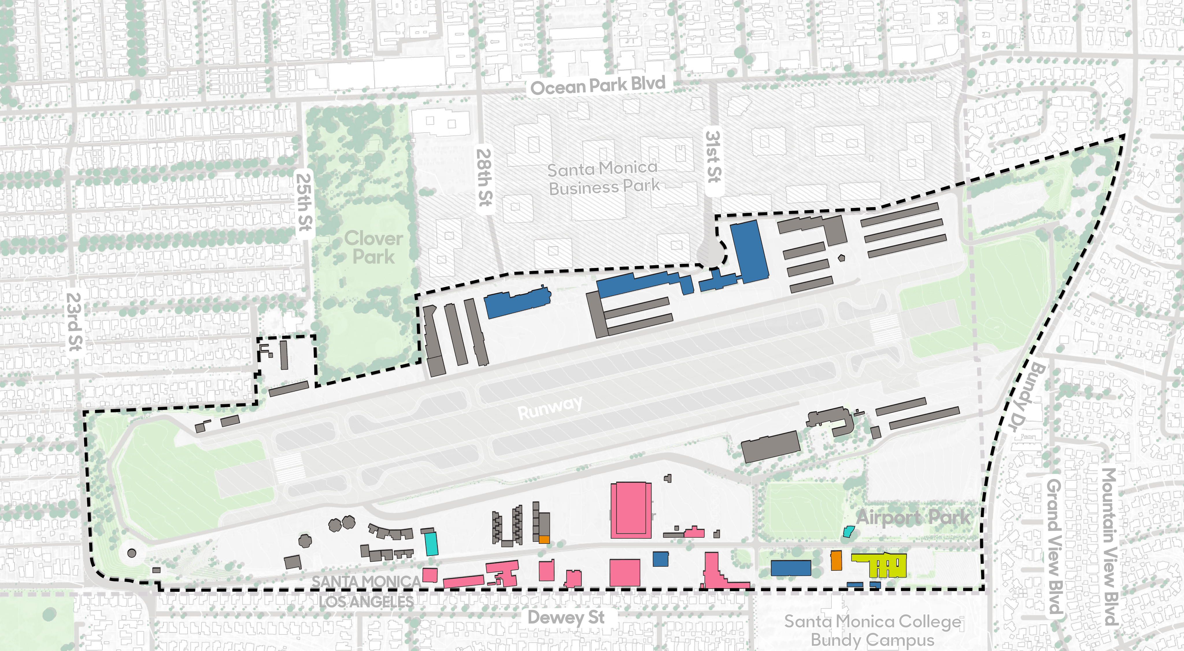
A variety of different uses and building types occupy the site today. In addition to aviation uses, the site is home to retail, art, cultural, institutional, and office facilities.
Retail / Restaurant
Arts/Culture/Institutional
Aviation Use
Office
Scheduled to be Demolished
Other
Site Materials
The Santa Monica Airport is 80% covered by impervious surfaces which include buildings, concrete, runway, plazas, and paths.
Pervious Surface
20%
Lawn
Sports Field
Interim landscape
Semi-Pervious Surface
80%
Building
Concrete & Asphalt
Tarmac
Plaza & Pathways
Site Topography
With the exception of the steep bluff drop off on the west side, the site is characterized by a relatively gentle east to west slope, which enables a clear view of the bay from many points of the property.
0-3 degrees
3-5
5-8
8-15
15-33
>33
Urban Centers
The site's proximity to the urban centers of Santa Monica and the larger Los Angeles region presents an exceptional opportunity for it to emerge as a well-connected community resource.
Ecology Connector
The site's location and topography play an important role in shaping Santa Monica's future ecological health, enabling better connectivity with the larger regional ecology.
The Opportunity
The Santa Monica Airport is strategically positioned to be reborn as a central community resource, with park and recreation offerings that feature captivating views of the mountains, ocean, and downtown Los Angeles.
Population Density
The airport site sits within the dense urban fabric of Santa Monica and Los Angeles's westside residential neighborhoods.
0-9,999
10,000-19,999
20,000-29,999
>30,000
People per sq. mile
Site Accessibility
Most Santa Monica residents can access the site via a 20-minute bike ride.
10 min walk
15 min walk
20 min walk
10 min bike
20 min bike
Site Hydrology
The Santa Monica Airport has a relatively low flood risk compared to other surrounding areas to the east.
Flow to Santa Monica Bay
Flow to Ballona Creek
Flood Risk
low-high
On-site Today
A variety of different uses and building types occupy the site today. In addition to aviation uses, the site is home to retail, art, cultural, institutional, and office facilities.
Retail / Restaurant
Arts/Culture/Institutional
Aviation Use
Office
Scheduled to be Demolished
Other
Site Materials
The Santa Monica Airport is 80% covered by impervious surfaces which include buildings, concrete, runway, plazas, and paths.
Pervious Surface
20%
Lawn
Sports Field
Interim landscape
Semi-Pervious Surface
80%
Building
Concrete & Asphalt
Tarmac
Plaza & Pathways
Site Topography
With the exception of the steep bluff drop off on the west side, the site is characterized by a relatively gentle east to west slope, which enables a clear view of the bay from many points of the property.
0-3 degrees
3-5
5-8
8-15
15-33
>33


EXISTING CONDITIONS
Project Site
Project Site
EXISTING CONDITIONS
Project Site

Urban Centers
The site's proximity to the urban centers of Santa Monica and the larger Los Angeles region presents an exceptional opportunity for it to emerge as a well-connected community resource.
Ecology Connector
The site's location and topography play an important role in shaping Santa Monica's future ecological health, enabling better connectivity with the larger regional ecology.
The Opportunity
The Santa Monica Airport is strategically positioned to be reborn as a central community resource, with park and recreation offerings that feature captivating views of the mountains, ocean, and downtown Los Angeles.
Population Density
The airport site sits within the dense urban fabric of Santa Monica and Los Angeles's westside residential neighborhoods.
0-9,999
10,000-19,999
20,000-29,999
>30,000
People per sq. mile
Site Accessibility
Most Santa Monica residents can access the site via a 20-minute bike ride.
10 min walk
15 min walk
20 min walk
10 min bike
20 min bike
Site Hydrology
The Santa Monica Airport has a relatively low flood risk compared to other surrounding areas to the east.
Flow to Santa Monica Bay
Flow to Ballona Creek
Flood Risk
low-high
On-site Today
A variety of different uses and building types occupy the site today. In addition to aviation uses, the site is home to retail, art, cultural, institutional, and office facilities.
Retail / Restaurant
Arts/Culture/Institutional
Aviation Use
Office
Scheduled to be Demolished
Other
Site Materials
The Santa Monica Airport is 80% covered by impervious surfaces which include buildings, concrete, runway, plazas, and paths.
Pervious Surface
20%
Lawn
Sports Field
Interim landscape
Semi-Pervious Surface
80%
Building
Concrete & Asphalt
Tarmac
Plaza & Pathways
Site Topography
With the exception of the steep bluff drop off on the west side, the site is characterized by a relatively gentle east to west slope, which enables a clear view of the bay from many points of the property.
0-3 degrees
3-5
5-8
8-15
15-33
>33
EXISTING CONDITIONS
City
EXISTING CONDITIONS
City
Urban Centers
The site's proximity to the urban centers of Santa Monica and the larger Los Angeles region presents an exceptional opportunity for it to emerge as a well-connected community resource.
Ecology Connector
The site's location and topography play an important role in shaping Santa Monica's future ecological health, enabling better connectivity with the larger regional ecology.
The Opportunity
The Santa Monica Airport is strategically positioned to be reborn as a central community resource, with park and recreation offerings that feature captivating views of the mountains, ocean, and downtown Los Angeles.
Population Density
The airport site sits within the dense urban fabric of Santa Monica and Los Angeles's westside residential neighborhoods.
0-9,999
10,000-19,999
20,000-29,999
>30,000
People per sq. mile
Site Accessibility
Most Santa Monica residents can access the site via a 20-minute bike ride.
10 min walk
15 min walk
20 min walk
10 min bike
20 min bike
Site Hydrology
The Santa Monica Airport has a relatively low flood risk compared to other surrounding areas to the east.
Flow to Santa Monica Bay
Flow to Ballona Creek
Flood Risk
low-high
On-site Today
A variety of different uses and building types occupy the site today. In addition to aviation uses, the site is home to retail, art, cultural, institutional, and office facilities.
Retail / Restaurant
Arts/Culture/Institutional
Aviation Use
Office
Scheduled to be Demolished
Other
Site Materials
The Santa Monica Airport is 80% covered by impervious surfaces which include buildings, concrete, runway, plazas, and paths.
Pervious Surface
20%
Lawn
Sports Field
Interim landscape
Semi-Pervious Surface
80%
Building
Concrete & Asphalt
Tarmac
Plaza & Pathways
Site Topography
With the exception of the steep bluff drop off on the west side, the site is characterized by a relatively gentle east to west slope, which enables a clear view of the bay from many points of the property.
0-3 degrees
3-5
5-8
8-15
15-33
>33
EXISTING CONDITIONS
Region
Region
EXISTING CONDITIONS
Region


Let's shape the future of Santa Monica Airport site together.
Built By


BUILT BY
Let's shape the future of Santa Monica Airport site together.
Built By
BUILT BY
Let's shape the future of Santa Monica Airport site together.
Built By
BUILT BY
Let's shape the future of Santa Monica Airport site together.
BUILT BY